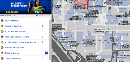
A new UC Riverside campus map makes it easier to get around campus with features such as step-by-step directions and a category menu for different types of resources.
The revamped UCR map website, which launched in late February, offers more interactive tools including wayfinding that provides walking or driving directions to any location at the 1,200-acre campus. It’s one of the key new features that was not available on the previous UCR map.
The map includes locations, descriptions, 360-degree panoramic photos, virtual tours, and listings of campus events. Clicking on an icon on the map will bring up photos, the location description, and the wayfinding toolbar.
Users can search for campus locations under different categories in a sidebar on the left of the screen. The options include simply searching under academic building names or more focused searches in categories such as administration, athletics/recreation, libraries, dining/shopping, and housing.
The map also has new options where users can search for gardens/relaxation spots, gender inclusive restrooms, water refill stations, and lactation rooms.
The website includes a short video tutorial on how to use the campus map.
“This is all part of an effort to improve wayfinding on campus,” said David Edgerton, assistant director of brand creative services with University Relations, who oversaw the map revamp.
The map development team is currently refining and improving the platform’s programmed pathways used to provide directions to campus locations.
UCR had previously created and maintained its campus map internally but the new version is on the Concept3D platform, the same company that operates the Localist platform that hosts the UCR Events Calendar.
That allows for integration between the two sites so that event listings include a map with a link for directions.
